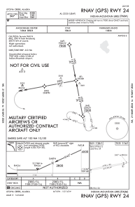


PAIM - Indian Mountain Lrrs
Located in Utopia Creek,
ICAO - UTO, IATA - UTO
Data provided by AirmateGeneral information
Coordinates: N65°59'34" W153°42'13"
Elevation is 1261 feet MSL.
Magnetic variation is 17° East View others Airports in Alaska
Operational data
Special qualification required
Current time UTC:
Current local time:
Weather
METAR: PAIM 090955Z AUTO 28004KT 10SM BKN050 BKN075 BKN085 04/02 A2975 RMK AO2 SHRAB0907E0909B0931E0943 SLP082 P0002 T00380018
Communications frequencies: [VIEW]
Runways:
| RWY identifier | QFU | Length (ft) | Width (ft) | Surface | LDA (ft) |
| 06 | 0° | 4100 | 150 | GRAVEL | |
| 24 | 0° | 4100 | 150 | GRAVEL |
Airport contact information
Address: Utopia Creek