


PAHO - Homer
Located in Homer,
ICAO - HOM, IATA - HOM
Data provided by AirmateGeneral information
Coordinates: N59°38'42" W151°29'9"
Elevation is 84 feet MSL.
Magnetic variation is 17° East View others Airports in Alaska
Operational data
Special qualification required
Current time UTC:
Current local time:
Weather
METAR: PAHO 091353Z 00000KT 10SM OVC075 02/00 A2992 RMK AO2 SLP132 T00220000
TAF: PAHO 091144Z 0912/1012 29006KT P6SM VCSH SCT035 TEMPO 0912/0916 4SM -SN BKN025
Communications frequencies: [VIEW]
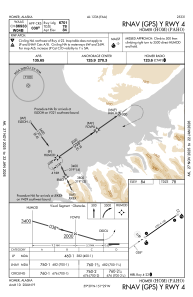
Runways:
| RWY identifier | QFU | Length (ft) | Width (ft) | Surface | LDA (ft) |
| 04 | 55° | 6701 | 150 | ASPH | |
| 22 | 235° | 6701 | 150 | ASPH | |
| 06W | 0° | 2501 | 100 | WATER | |
| 24W | 0° | 2501 | 100 | WATER |
Airport contact information
Address: Homer