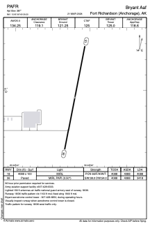


PAFR - Bryant Aaf
Located in Fort Richardson (Anchorage),
ICAO - FRN, IATA - FRN
Data provided by AirmateGeneral information
Coordinates: N61°15'57" W149°39'12"
Elevation is 387 feet MSL.
Magnetic variation is 15° East View others Airports in Alaska
Operational data
Special qualification required
Current time UTC:
Current local time:
Weather
METAR: PAFR 090755Z AUTO 20006KT 9SM OVC008 01/00 A2997 RMK AO2 SNE08SNB20E33SNB41E53 CIG 006V008 OVC V BKN SLP157 P0000 T00090000 $
Communications frequencies: [VIEW]
Runways:
| RWY identifier | QFU | Length (ft) | Width (ft) | Surface | LDA (ft) |
| 18 | 191° | 4088 | 100 | ASPH | 4088 |
| 36 | 11° | 4088 | 100 | ASPH | 3418 |
Airport contact information
Address: Fort Richardson (Anchorage)