


PADQ - Kodiak
Located in Kodiak,
ICAO - ADQ, IATA - ADQ
Data provided by AirmateGeneral information
Coordinates: N57°44'59" W152°29'38"
Elevation is 79 feet MSL.
Magnetic variation is 14° East View others Airports in Alaska
Operational data
Special qualification required
Current time UTC:
Current local time:
Weather
METAR: PADQ 091153Z AUTO 29004KT 10SM CLR M03/M04 A2994 RMK AO2 SLP140 70001 T10281044 10017 21028 58004 TSNO
TAF: PADQ 091144Z 0912/1012 VRB06KT P6SM SCT035 FM091800 15011KT 6SM -SHRASN BR SCT015 BKN025 FM100200 24006KT P6SM VCSH SCT040
Communications frequencies: [VIEW]
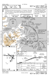
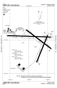
Runways:
| RWY identifier | QFU | Length (ft) | Width (ft) | Surface | LDA (ft) |
| 01 | 22° | 5010 | 150 | ASPH | |
| 19 | 202° | 5010 | 150 | ASPH | |
| 08 | 92° | 7534 | 150 | ASPH | 6396 |
| 26 | 272° | 7534 | 150 | ASPH | 7534 |
| 11 | 127° | 5400 | 150 | ASPH | 4402 |
| 29 | 307° | 5400 | 150 | ASPH | 4402 |
Airport contact information
Address: Kodiak