


P13 - San Carlos Apache
Located in Globe, United States
ICAO - P13, IATA -
Data provided by AirmateGeneral information
Coordinates: N33°21'11" W110°40'2"
Elevation is 3261 feet MSL.
Magnetic variation is 12° East View others Airports in Arizona
Operational data
Special qualification required
Current time UTC:
Current local time:
Weather at : - ( 0 km )
METAR: OPLA 172025Z 00000KT 5000 HZ NSC 33/17 Q1003 NOSIG RMK QFE977 A29.63
Communications frequencies: [VIEW]
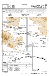
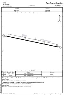
Runways:
| RWY identifier | QFU | Length (ft) | Width (ft) | Surface | LDA (ft) |
| 09 | 102° | 6500 | 100 | ASPH | |
| 27 | 282° | 6500 | 100 | ASPH |
Airport contact information
Address: Globe United States