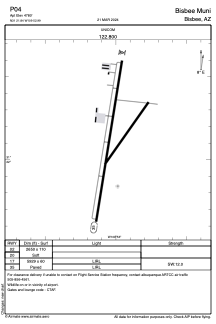


P04 - Bisbee Muni
Located in Bisbee, United States
ICAO - P04, IATA -
Data provided by AirmateGeneral information
Coordinates: N31°21'50" W109°52'59"
Elevation is 4780 feet MSL.
Magnetic variation is 12° East View others Airports in Arizona
Operational data
Special qualification required
Current time UTC:
Current local time:
Weather at : KDUG - Bisbee Douglas Intl ( 29 km )
METAR: KDUG 172256Z AUTO 31010G17KT 10SM CLR 31/M03 A2992 RMK AO2 SLP065 T03061033 TSNO
TAF: KDUG 171720Z 1718/1818 31008G17KT P6SM SKC FM171900 31009G18KT P6SM SCT130 FM180300 35006KT P6SM SKC FM181100 VRB03KT P6SM SKC
Communications frequencies: [VIEW]
Runways:
| RWY identifier | QFU | Length (ft) | Width (ft) | Surface | LDA (ft) |
| 02 | 0° | 2650 | 110 | EARTH | |
| 20 | 0° | 2650 | 110 | EARTH | |
| 17 | 0° | 5929 | 60 | ASPH | |
| 35 | 0° | 5929 | 60 | ASPH |
Airport contact information
Address: Bisbee United States
Other aviation service providers
Flight schools

Copper City Aviation Services, Llc.
Copper City Aviation Services, Llc.
eric@coppercityaviation.com+1(520)266-0515