


OITL - Ardabil / Secondary International Aerodrome
Located in Ardabil, Iran, Islamic Republic of
ICAO - OITL, IATA - ADU
Data provided by AirmateGeneral information
Coordinates: N38°19'36" E48°25'27"
Elevation is 4319 feet MSL.
View others Airports in Ardabil Province
Operational data
Special qualification required
Current time UTC:
Current local time:
Weather
METAR: OITL 151300Z 08016KT 9999 VCFG FEW010 SCT030TCU BKN170 12/09 Q1017 NOSIG
TAF: TAF OITL 151110Z 1512/1521 07008KT 8000 FEW010 SCT030 BKN100 TEMPO 1512/1515 07012G22KT 5000 RA/SHRA VCFG/BR SCT010 BKN030 FEW035TCU SCT040CB BKN090 TEMPO 1515/1521 09014G24KT 4000 BR BKN010 BKN025 FEW030TCU FEW035CB BKN080 PROB30 TEMPO 1517/1521 2000 BR OVC005 BKN020
Communications frequencies: [VIEW]
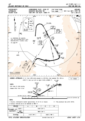
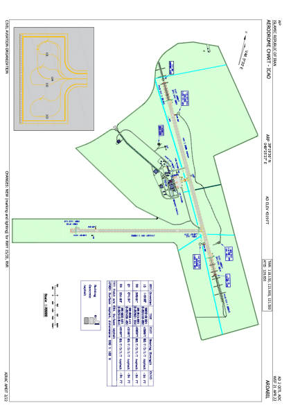
Runways:
| RWY identifier | QFU | Length (ft) | Width (ft) | Surface | LDA (ft) |
| 07 | 75° | 8202 | 148 | UNK | |
| 25 | 255° | 8202 | 148 | UNK | |
| 15 | 150° | 10820 | 148 | PEM | |
| 33 | 330° | 10820 | 148 | PEM |
Airport contact information
Address: Ardabil Iran, Islamic Republic of