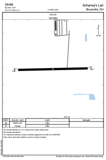


OH46 - Schaney's Lair
Located in Brookville, United States
ICAO - OH46, IATA -
Data provided by AirmateGeneral information
Coordinates: N39°51'35" W84°26'7"
Elevation is 1037 feet MSL.
Magnetic variation is -04° East View others Airports in Ohio
Operational data
Special qualification required
Current time UTC:
Current local time:
Weather at : KDAY - James M Cox Dayton Intl ( 19 km )
METAR: KDAY 081219Z 23007KT 5SM BR BKN005 18/17 A2976 RMK AO2 T01780172
TAF: KDAY 081216Z 0812/0912 22006KT 4SM BR BKN004 FM081300 25006KT P6SM SCT250 TEMPO 0813/0814 2SM BR BKN006 FM090200 10005KT P6SM -SHRA OVC120 FM090600 12005KT P6SM -SHRA OVC027 FM090800 10006KT P6SM VCSH OVC014
Communications frequencies: [VIEW]
Runways:
| RWY identifier | QFU | Length (ft) | Width (ft) | Surface | LDA (ft) |
| 09 | 0° | 2445 | 30 | ASPH | |
| 27 | 0° | 2445 | 30 | ASPH |
Airport contact information
Address: Brookville United States