
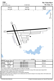


O88 - Rio Vista Muni
Located in Rio Vista, United States
ICAO - O88, IATA -
Data provided by AirmateGeneral information
Coordinates: N38°11'36" W121°42'13"
Elevation is 23 feet MSL.
Magnetic variation is 14° East View others Airports in California
Operational data
Special qualification required
Current time UTC:
Current local time:
Weather at : KSUU - Travis Afb ( 21 km )
METAR: KSUU 091855Z AUTO 03017G21KT 10SM CLR 26/03 A2992 RMK AO2 PK WND 04026/28 SLP138 T02610033 $
TAF: TAF KSUU 091900Z 0919/1101 01015G25KT 9999 SKC QNH2992INS BECMG 0919/0920 01010G15KT 9999 SKC QNH2986INS BECMG 0922/0923 01009KT 9999 SKC QNH2985INS BECMG 1000/1001 VRB06KT 9999 SKC QNH2985INS BECMG 1003/1004 26010G15KT 9999 SKC QNH2989INS BECMG 1014/1015 01010G15KT 9999 SKC QNH2983INS TX32/1000Z TN12/1013Z
Communications frequencies: [VIEW]
Runways:
| RWY identifier | QFU | Length (ft) | Width (ft) | Surface | LDA (ft) |
| 07 | 86° | 4199 | 75 | ASPH | |
| 25 | 266° | 4199 | 75 | ASPH | |
| 15 | 160° | 2199 | 60 | ASPH | |
| 33 | 340° | 2199 | 60 | ASPH |
Airport contact information
Address: Rio Vista United States
