


NTMU - Ua Huka
Located in Hane, French Polynesia
ICAO - NTMU, IATA - UAH
Data provided by AirmateGeneral information
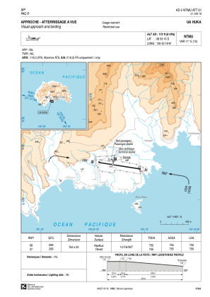
Coordinates: S8°56'10" W139°33'18"
Elevation is 173 feet MSL.
Magnetic variation is 10.65° East View others Airports in (unassigned)
Operational data
Special qualification required
Current time UTC:
Current local time:
Weather at : - ( 0 km )
METAR: CYOO 151007Z AUTO 02007KT 9SM OVC026 13/10 A2981 RMK SLP098
Communications frequencies: [VIEW]
Runways:
| RWY identifier | QFU | Length (ft) | Width (ft) | Surface | LDA (ft) |
| 09 | 99° | 2477 | 66 | ASPH | 2477 |
| 27 | 279° | 2477 | 66 | ASPH | 2477 |
Airport contact information
Address: Hane French Polynesia