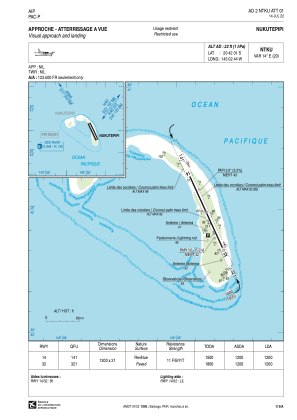


NTKU - Nukutepipi
Located in , French Polynesia
ICAO - NTKU, IATA - NKP
Data provided by AirmateGeneral information
Coordinates: S20°42'1" W143°2'44"
Elevation is 22 feet MSL.
Magnetic variation is 13.89° East View others Airports in (unassigned)
Operational data
Special qualification required
Current time UTC:
Current local time:
Weather at : - ( 0 km )
METAR: CYSC 152142Z AUTO 09007KT 2 1/2SM RA BR FEW011 BKN021 BKN027 OVC040 16/14 A2982 RMK VIS VRB 1 1/4-3 LTNG DIST S PCPN 8.1MM PAST HR SLP101 DENSITY ALT 1200FT
Communications frequencies: [VIEW]
Runways:
| RWY identifier | QFU | Length (ft) | Width (ft) | Surface | LDA (ft) |
| 14 | 155° | 3937 | 69 | ASPH | 3937 |
| 32 | 335° | 3937 | 69 | ASPH | 3937 |
Airport contact information
Address: French Polynesia