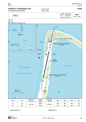


NTGY - Tureia
Located in Fakamaru, French Polynesia
ICAO - NTGY, IATA - ZTA
Data provided by AirmateGeneral information
Coordinates: S20°46'48" W138°34'1"
Elevation is 10 feet MSL.
Magnetic variation is 13.78° East View others Airports in (unassigned)
Operational data
Special qualification required
Current time UTC:
Current local time:
Weather at : - ( 0 km )
METAR: KHNB 152308Z AUTO 29010G14KT SCT019 BKN055 OVC090 19/18 A2980 RMK AO2 PWINO PNO $
Communications frequencies: [VIEW]
Runways:
| RWY identifier | QFU | Length (ft) | Width (ft) | Surface | LDA (ft) |
| 18 | 192° | 4265 | 98 | ASPH | 3675 |
| 36 | 12° | 4265 | 98 | ASPH | 4265 |
Airport contact information
Address: Fakamaru French Polynesia