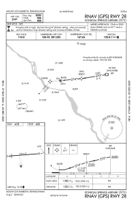
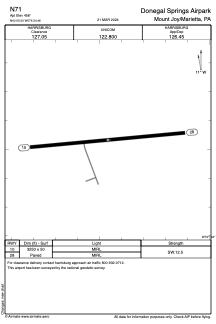


N71 - Donegal Springs Airpark
Located in Mount Joy/Marietta, United States
ICAO - N71, IATA -
Data provided by AirmateGeneral information
Coordinates: N40°5'32" W76°34'28"
Elevation is 458 feet MSL.
Magnetic variation is -09° East View others Airports in Pennsylvania
Operational data
Special qualification required
Current time UTC:
Current local time:
Weather at : KMDT - Harrisburg Intl ( 20 km )
METAR: KMDT 091256Z 02009KT 10SM BKN150 18/10 A2973 RMK AO2 SLP067 T01780100
TAF: KMDT 091120Z 0912/1012 30007KT P6SM BKN140 FM091300 05007KT P6SM OVC090 FM091700 06007KT P6SM VCSH OVC040 FM091900 05007KT P6SM -RA OVC030 FM092300 06007KT 5SM -RA BR OVC025 FM100300 04005KT 4SM -RA BR OVC015 FM100700 09005KT 4SM -RA BR OVC007
Communications frequencies: [VIEW]
Runways:
| RWY identifier | QFU | Length (ft) | Width (ft) | Surface | LDA (ft) |
| 10 | 85° | 3250 | 50 | ASPH | |
| 28 | 265° | 3250 | 50 | ASPH |
Airport contact information
Address: Mount Joy/Marietta United States