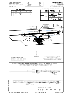


MMVA - Villahermosa Aeropuerto Internacional C.P.A. Carlos Rovirosa
Located in Villahermosa, Mexico
ICAO - MMVA, IATA - VSA
Data provided by AirmateGeneral information
Coordinates: N17°59'49" W92°48'53"
Elevation is 46 feet MSL.
View others Airports in Tabasco
Operational data
Special qualification required
Current time UTC:
Current local time:
Weather
TAF: TAF MMVA 160537Z 1606/1706 00000KT 5SM HZ SKC TEMPO 1610/1614 3SM BR HZ SCT015 FM161500 11005KT 5SM HZ SCT210 FM162100 32010KT 6SM HZ SCT070 SCT210
Communications frequencies: [VIEW]
Runways:
| RWY identifier | QFU | Length (ft) | Width (ft) | Surface | LDA (ft) |
| 08 | 87° | 7218 | 148 | ASP | |
| 26 | 267° | 7218 | 148 | ASP |
Airport contact information
Address: Villahermosa Mexico