


MMUN - Cancun Aeropuerto Internacional
Located in Cancun, Mexico
ICAO - MMUN, IATA - CUN
Data provided by AirmateGeneral information
Coordinates: N21°2'34" W86°52'24"
Elevation is 22 feet MSL.
View others Airports in Quintana Roo
Operational data
Special qualification required
Current time UTC:
Current local time:
Weather
METAR: MMUN 161447Z 17016KT 7SM SCT015 SCT250 31/25 A2988 RMK SLP120 52006 951 8/102
TAF: TAF MMUN 161121Z 1612/1712 15010KT P6SM SCT015 TX32/1621Z TN27/1613Z FM161400 15015KT P6SM SCT015 FM162000 13010KT P6SM BKN015 FM170000 12010KT P6SM SCT015 FM170600 15010KT P6SM BKN015
Communications frequencies: [VIEW]
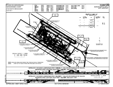
Runways:
| RWY identifier | QFU | Length (ft) | Width (ft) | Surface | LDA (ft) |
| 12R | 124° | 11483 | 197 | ASP | |
| 30L | 304° | 11483 | 197 | ASP | |
| 12L | 124° | 9186 | 148 | ASP | |
| 30R | 304° | 9186 | 148 | ASP |
Airport contact information
Address: Cancun Mexico