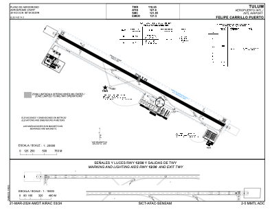


MMTL - Aeropuerto Internacional De Tulum Felipe Carrillo Puerto
Located in Quintana Roo, Mexico
ICAO - , IATA -
Data provided by AirmateGeneral information
Coordinates: N20°10'21" W87°39'40"
Elevation is 47 feet MSL.
View others Airports in Quintana Roo
Operational data
Special qualification required
Current time UTC:
Current local time:
Weather at : - ( 0 km )
METAR: KTPL 162126Z AUTO 04015G21KT VCTS SCT011 BKN029 OVC070 18/18 A2968 RMK AO2 WSHFT 2038 LTG DSNT ALQDS P0039 PWINO RVRNO $
Communications frequencies: [VIEW]
Runways:
| RWY identifier | QFU | Length (ft) | Width (ft) | Surface | LDA (ft) |
| 12 | 120° | 12139 | 148 | UNK | |
| 30 | 300° | 12139 | 148 | UNK |
Airport contact information
Address: Quintana Roo Mexico