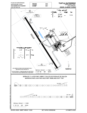


MMTG - Tuxtla Gutierrez Aeropuerto Internacional Angel Albino Corzo
Located in Tuxtla Gutierrez, Mexico
ICAO - MMTG, IATA - TGZ
Data provided by AirmateGeneral information
Coordinates: N16°33'43" W93°1'34"
Elevation is 1506 feet MSL.
View others Airports in Chiapas
Operational data
Special qualification required
Current time UTC:
Current local time:
Weather
METAR: MMTG 161103Z RTD 22006KT 6SM SKC 23/19 A2992 RMK HZY RTS
TAF: TAF MMTG 160521Z 1606/1706 21005KT 6SM HZ SCT300 FM160900 00000KT 6SM HZ SCT090 SCT300 TEMPO 1611/1615 4SM HZ BKN015 FM161800 30010KT P6SM SCT020 TEMPO 1620/1624 SCT020CB FM170000 27010KT P6SM BKN080
Communications frequencies: [VIEW]
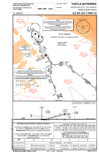
Runways:
| RWY identifier | QFU | Length (ft) | Width (ft) | Surface | LDA (ft) |
| 15 | 148° | 8202 | 148 | UNK | |
| 33 | 328° | 8202 | 148 | UNK |
Airport contact information
Address: Tuxtla Gutierrez Mexico