


MMJC - Atizapan De Zaragoza
Located in Mexico City, Mexico
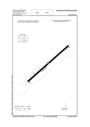
ICAO - MMJC, IATA - AZP
Data provided by AirmateGeneral information
Coordinates: N19°34'29" W99°17'20"
Elevation is 8120 feet MSL.
View others Airports in Mexico
Operational data
Special qualification required
Current time UTC:
Current local time:
Weather at : MMMX - Mexico Aeropuerto Internacional Benito Juarez ( 27 km )
METAR: MMMX 162045Z 12012G22KT 6SM SCT020TCU BKN080 BKN220 29/08 A3014 NOSIG RMK SLP010 57022 951 8/238 HZY DSNT CB E NE AND S SW
TAF: TAF MMMX 161720Z 1618/1718 13010KT P6SM SCT025 TX30/1621Z TN15/1712Z FM162200 22010G20KT P6SM VC RA BKN025CB TEMPO 1623/1703 VRB25KT 4SM TSRA/GR FM170300 00000KT P6SM SCT080 FM171300 00000KT 5SM HZ SKC
Communications frequencies: [VIEW]
Runways:
| RWY identifier | QFU | Length (ft) | Width (ft) | Surface | LDA (ft) |
| 04 | 47° | 4265 | 131 | ASP | |
| 22 | 227° | 4265 | 131 | ASP |
Airport contact information
Address: Mexico City Mexico