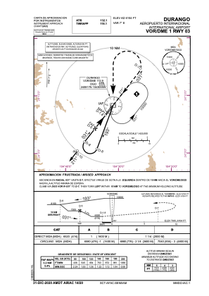
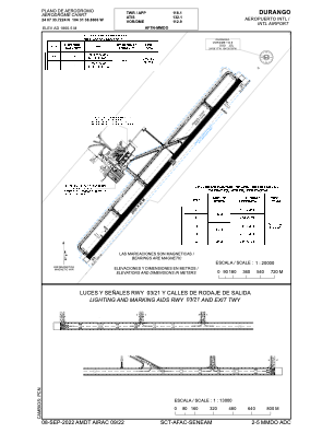


MMDO - Durango Aeropuerto Internacional
Located in Durango, Mexico
ICAO - MMDO, IATA - DGO
Data provided by AirmateGeneral information
Coordinates: N24°7'34" W104°31'39"
Elevation is 6104 feet MSL.
View others Airports in Durango
Operational data
Special qualification required
Current time UTC:
Current local time:
Weather
METAR: MMDO 161341Z 22006KT 9SM FEW090 SCT200 18/02 A3017 RMK 8/011
TAF: TAF MMDO 160522Z 1606/1706 20005KT P6SM SCT200 FM161800 23015KT P6SM SCT200 TEMPO 1622/1702 24010G25KT SCT100 BKN200 FM170300 24006KT P6SM BKN200
Communications frequencies: [VIEW]
Runways:
| RWY identifier | QFU | Length (ft) | Width (ft) | Surface | LDA (ft) |
| 03 | 38° | 9534 | 148 | ASP | |
| 21 | 218° | 9534 | 148 | ASP |
Airport contact information
Address: Durango Mexico