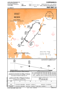
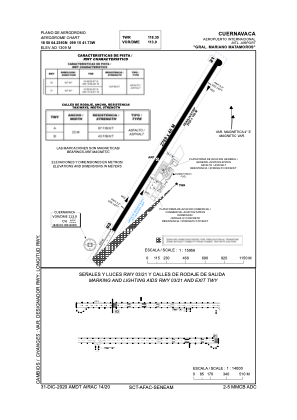


MMCB - Cuernavaca Aeropuerto Internacional Gral. Mariano Matamoros
Located in Cuernavaca, Mexico
ICAO - MMCB, IATA - CVJ
Data provided by AirmateGeneral information
Coordinates: N18°50'4" W99°15'42"
Elevation is 4295 feet MSL.
View others Airports in Moreloa
Operational data
Special qualification required
Current time UTC:
Current local time:
Weather
METAR: MMCB 161442Z 16005KT 4SM SCT220 27/14 A3008 RMK 8/008 HZY
TAF: TAF MMCB 160455Z 1606/1706 04004KT 4SM HZ SCT100 FM161000 35005KT 3SM HZ SKC TEMPO 1612/1615 2SM FU HZ FM161800 18010KT 4SM HZ SCT030 TEMPO 1621/1701 VC RA SCT020CB
Communications frequencies: [VIEW]
Runways:
| RWY identifier | QFU | Length (ft) | Width (ft) | Surface | LDA (ft) |
| 03 | 32° | 9180 | 148 | UNK | |
| 21 | 212° | 9180 | 148 | UNK |
Airport contact information
Address: Cuernavaca Mexico