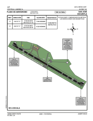


MGSJ - San Jose Escuintla
Located in Escuintla, Guatemala
ICAO - MGSJ, IATA - GSJ
Data provided by AirmateGeneral information
Coordinates: N13°56'10" W90°50'9"
Elevation is 17 feet MSL.
Magnetic variation is 1° East View others Airports in Escuintla
Operational data
Special qualification required
Current time UTC:
Current local time:
Weather at : MGGT - La Aurora ( 79 km )
METAR: MGGT 211400Z 04008KT 3000 HZ SCT014 22/18 Q1020 A3012
TAF: MGGT 211100Z 2112/2212 00000KT 4000 BR SCT014 TX30/2120Z TN20/2112Z BECMG 2114/2116 18008KT 6000 SCT018 BECMG 2118/2120 SCT020 TEMPO 2121/2201 VCTS SCT020TCU FEW025CB BECMG 2201/2203 00000KT SCT016 TEMPO 2206/2212 BKN016
Communications frequencies: [VIEW]
Runways:
| RWY identifier | QFU | Length (ft) | Width (ft) | Surface | LDA (ft) |
| 15 | 157° | 6620 | 138 | ASPH | |
| 33 | 337° | 6620 | 138 | ASPH |
Airport contact information
Address: Escuintla Guatemala