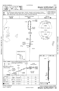


M79 - John H Hooks Jr Meml
Located in Rayville, United States
ICAO - M79, IATA -
Data provided by AirmateGeneral information
Coordinates: N32°29'8" W91°46'16"
Elevation is 83 feet MSL.
Magnetic variation is 02° East View others Airports in Louisiana
Operational data
Special qualification required
Current time UTC:
Current local time:
Weather at : KMLU - Monroe Rgnl ( 25 km )
METAR: KMLU 090853Z AUTO 18005KT 8SM CLR 24/23 A2970 RMK AO2 SLP057 T02440228 55007
TAF: KMLU 090804Z 0908/1006 19005KT P6SM SCT015 SCT050 SCT250 TEMPO 0910/0913 3SM BR BKN005 FM091300 21003KT 3SM BR BKN005 TEMPO 0913/0916 P6SM NSW BKN015 FM091600 VRB06KT P6SM BKN025 FM091800 VRB06KT P6SM BKN040 FM100300 VRB06KT P6SM VCTS BKN040CB
Communications frequencies: [VIEW]
Runways:
| RWY identifier | QFU | Length (ft) | Width (ft) | Surface | LDA (ft) |
| 18 | 182° | 3998 | 75 | ASPH | |
| 36 | 2° | 3998 | 75 | ASPH |
Airport contact information
Address: Rayville United States