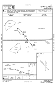
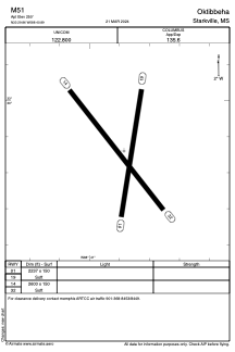


M51 - Oktibbeha
Located in Starkville, United States
ICAO - M51, IATA -
Data provided by AirmateGeneral information
Coordinates: N33°29'52" W88°40'53"
Elevation is 250 feet MSL.
Magnetic variation is 02° East View others Airports in Mississippi
Operational data
Special qualification required
Current time UTC:
Current local time:
Weather at : KGTR - Golden Triangle Rgnl ( 10 km )
METAR: KGTR 091056Z 18005KT 9SM SCT031 23/23 A2976 RMK AO2 SLP082 T02330228
TAF: KGTR 090523Z 0906/1006 19008KT P6SM SCT250 WS020/21040KT FM090800 19007KT P6SM BKN022 FM091300 21007KT 6SM SHRA BR BKN009 TEMPO 0913/0914 4SM +TSRA BR OVC004CB FM091400 24007KT P6SM VCTS BKN011CB FM092000 28007KT P6SM FEW070
Communications frequencies: [VIEW]
Runways:
| RWY identifier | QFU | Length (ft) | Width (ft) | Surface | LDA (ft) |
| 01 | 8° | 2237 | 150 | GRASS | |
| 19 | 188° | 2237 | 150 | GRASS | |
| 14 | 142° | 2600 | 150 | GRASS | |
| 32 | 322° | 2600 | 150 | GRASS |
Airport contact information
Address: Starkville United States