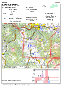


LZDN - Dobra Niva
Located in Dobr, Slovakia
ICAO - , IATA -
Data provided by AirmateGeneral information
Coordinates: N48°29'20" E19°6'6"
Elevation is 1145 feet MSL.
Magnetic variation is 5.29° East View others Airports in Banská Bystrica
Operational data
Special qualification required
Current time UTC:
Current local time:
Weather at : LZSL - Sliac ( 17 km )
TAF: TAF LZSL 130430Z 1306/1318 VRB02KT CAVOK BECMG 1311/1313 16006KT 9999 FEW050
Communications frequencies: [VIEW]
Runways:
| RWY identifier | QFU | Length (ft) | Width (ft) | Surface | LDA (ft) |
| 17 | 0° | 1640 | 39 | ASPH | |
| 35 | 0° | 1640 | 39 | ASPH |
Airport contact information
Address: Dobr Slovakia
Web: http://lsk.sk/