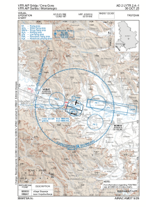
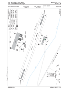


LYTR - Trstenik
Located in , Serbia and Montenegro
ICAO - LYTR, IATA -
Data provided by AirmateGeneral information
Coordinates: N43°36'51" E21°1'49"
Elevation is 534 feet MSL.
Magnetic variation is 5° East View others Airports in Rasina
Operational data
Special qualification required
Current time UTC:
Current local time:
Weather at : LYKV - Kraljevo / Morava ( 42 km )
METAR: LYKV 110700Z VRB02KT CAVOK 14/08 Q1020 NOSIG
TAF: TAF LYKV 110500Z 1106/1206 02008KT CAVOK TX20/1113Z TN07/1204Z
Communications frequencies: [VIEW]
Runways:
| RWY identifier | QFU | Length (ft) | Width (ft) | Surface | LDA (ft) |
| 11 | 0° | 5161 | 262 | UNK | |
| 29 | 0° | 5161 | 262 | UNK |
Airport contact information
Address: Serbia and Montenegro