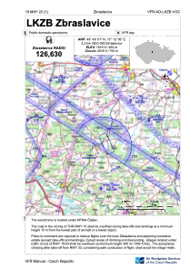
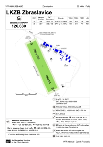


LKZB - Zbraslavice
Located in Zbraslavice, Czech Republic
ICAO - LKZB, IATA -
Data provided by AirmateGeneral information
Coordinates: N49°48'51" E15°12'6"
Elevation is 1618 feet MSL.
View others Airports in Central Bohemian Region
Operational data
Special qualification required
Current time UTC:
Current local time:
Weather at : LKCV - Caslav ( 19 km )
METAR: LKCV 101200Z 30005KT 230V340 CAVOK 18/05 Q1023 NOSIG RMK BLU BLU
TAF: TAF LKCV 101100Z 1012/1112 VRB02KT CAVOK TEMPO 1012/1018 35006KT TEMPO 1109/1112 14005KT SCT035
Communications frequencies: [VIEW]
Runways:
| RWY identifier | QFU | Length (ft) | Width (ft) | Surface | LDA (ft) |
| 15 | 0° | 2559 | 312 | UNK | |
| 33 | 0° | 2559 | 312 | UNK |
Airport contact information
Address: Zbraslavice Czech Republic
