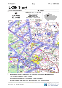
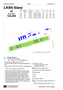


LKSN - Slany
Located in Slany, Czech Republic
ICAO - LKSN, IATA -
Data provided by AirmateGeneral information
Coordinates: N50°13'0" E14°5'19"
Elevation is 1079 feet MSL.
View others Airports in Central Bohemian Region
Operational data
Special qualification required
Current time UTC:
Current local time:
Weather at : LKPR - Praha/Ruzyne ( 18 km )
METAR: LKPR 112030Z 04007KT CAVOK 16/09 Q1021 NOSIG
TAF: TAF LKPR 112000Z 1121/1303 04006KT CAVOK TEMPO 1203/1206 5000 BR SCT007 PROB30 TEMPO 1203/1206 2500 MIFG BR BKN003 PROB30 TEMPO 1210/1216 9999 -SHRA SCT040TCU BECMG 1211/1213 11008KT
Communications frequencies: [VIEW]
Runways:
| RWY identifier | QFU | Length (ft) | Width (ft) | Surface | LDA (ft) |
| 07R | 0° | 2493 | 131 | UNK | |
| 25L | 0° | 2493 | 131 | UNK | |
| 07L | 0° | 2493 | 75 | UNK | |
| 25R | 0° | 2493 | 75 | UNK |
Airport contact information
Address: Slany Czech Republic
