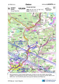
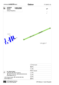


LKOSTR - Ostrov
Located in Ostrov Na Ohrí, Czech Republic
ICAO - , IATA -
Data provided by AirmateGeneral information
Coordinates: N50°20'12" E12°58'11"
Elevation is 1676 feet MSL.
Magnetic variation is 3° East View others Airports in Carlsbad Region
Operational data
Special qualification required
Current time UTC:
Current local time:
Weather at : LKKV - Karlovy Vary ( 15 km )
METAR: LKKV 101400Z 33005KT 280V360 CAVOK 19/01 Q1022
TAF: TAF LKKV 101100Z 1012/1112 VRB02KT CAVOK TEMPO 1012/1018 08007KT 9999 SCT040 TEMPO 1109/1112 9999 BKN040
Communications frequencies: [VIEW]
Runways:
| RWY identifier | QFU | Length (ft) | Width (ft) | Surface | LDA (ft) |
| 07 | 65° | 1640 | 49 | GRASS | 1640 |
| 25 | 245° | 1640 | 49 | GRASS | 1640 |
Airport contact information
Address: Ostrov Na Ohrí Czech Republic