


LKOPAV - Opava
Located in Opava, Czech Republic
ICAO - , IATA -
Data provided by AirmateGeneral information
Coordinates: N49°56'28" E17°58'59"
Elevation is 873 feet MSL.
View others Airports in Moravian-Silesian Region
Operational data
Special qualification required
Current time UTC:
Current local time:
Weather at : LKMT - Ostrava/Mosnov ( 29 km )
METAR: LKMT 110930Z 06004KT 010V100 9999 SCT040 18/10 Q1022 NOSIG
TAF: TAF LKMT 110500Z 1106/1206 VRB02KT CAVOK BECMG 1110/1112 02008KT 9999 BKN035 TEMPO 1114/1118 -SHRA SCT030TCU PROB30 TEMPO 1114/1117 36012G24KT 7000 -TSRA SCT030CB
Communications frequencies: [VIEW]
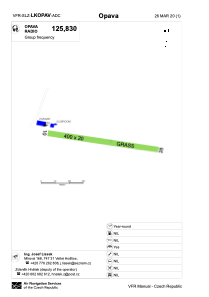
Runways:
| RWY identifier | QFU | Length (ft) | Width (ft) | Surface | LDA (ft) |
| 10 | 101° | 1312 | 66 | GRASS | 1312 |
| 28 | 281° | 1312 | 66 | GRASS | 1312 |
Airport contact information
Address: Opava Czech Republic
Web: lkopava.webnode.cz