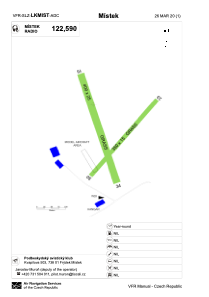


LKMIST - Mistek
Located in 3 Km S Frýdek - Místek Frýdek - Místek, Czech Republic
ICAO - , IATA -
Data provided by AirmateGeneral information
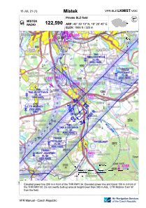
Coordinates: N49°39'10" E18°20'45"
Elevation is 1066 feet MSL.
View others Airports in Moravian-Silesian Region
Operational data
Special qualification required
Current time UTC:
Current local time:
Weather at : LKMT - Ostrava/Mosnov ( 18 km )
METAR: LKMT 120930Z 03011KT CAVOK 16/02 Q1022 NOSIG
TAF: TAF LKMT 120500Z 1206/1306 03008KT CAVOK BECMG 1223/1301 VRB02KT
Communications frequencies: [VIEW]
Runways:
| RWY identifier | QFU | Length (ft) | Width (ft) | Surface | LDA (ft) |
| 05 | 44° | 1148 | 49 | GRASS | 1148 |
| 23 | 224° | 1148 | 49 | GRASS | 1148 |
| 16 | 164° | 1312 | 82 | GRASS | 1312 |
| 34 | 344° | 1312 | 82 | GRASS | 1312 |
Airport contact information
Address: 3 Km S Frýdek - Místek Frýdek - Místek Czech Republic