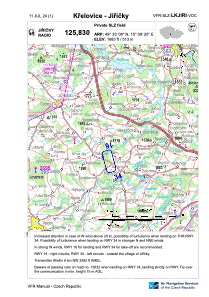


LKJIRI - Křelovice - Jiřičky
Located in Pelhřimov, Czech Republic
ICAO - , IATA -
Data provided by AirmateGeneral information
Coordinates: N49°33'8" E15°9'20"
Elevation is 1683 feet MSL.
View others Airports in Vysocina Region
Operational data
Special qualification required
Current time UTC:
Current local time:
Weather at : LKCV - Caslav ( 46 km )
METAR: LKCV 112300Z VRB02KT CAVOK 12/11 Q1021 NOSIG
TAF: TAF LKCV 111700Z 1118/1218 VRB02KT CAVOK PROB40 TEMPO 1118/1120 35010KT 7000 SHRA SCT030TCU BKN035 PROB30 TEMPO 1201/1206 4000 BR TEMPO 1206/1212 SCT025 BECMG 1207/1209 11008KT
Communications frequencies: [VIEW]
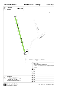
Runways:
| RWY identifier | QFU | Length (ft) | Width (ft) | Surface | LDA (ft) |
| 16 | 168° | 1969 | 66 | GRASS | |
| 34 | 348° | 1969 | 66 | GRASS |
Airport contact information
Address: Pelhřimov Czech Republic