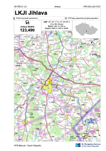
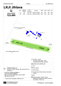


LKJI - Jihlava
Located in Jihlava, Czech Republic
ICAO - LKJI, IATA -
Data provided by AirmateGeneral information
Coordinates: N49°25'11" E15°38'8"
Elevation is 1821 feet MSL.
View others Airports in Vysocina Region
Operational data
Special qualification required
Current time UTC:
Current local time:
Weather at : LKNA - Namest ( 45 km )
METAR: LKNA 111830Z 36004KT CAVOK 17/08 Q1020 RMK BLACK
TAF: TAF LKNA 111700Z 1118/1218 02006KT CAVOK TEMPO 1122/1215 9999 SCT035 BECMG 1204/1206 09008KT
Communications frequencies: [VIEW]
Runways:
| RWY identifier | QFU | Length (ft) | Width (ft) | Surface | LDA (ft) |
| 10 | 0° | 3018 | 328 | Grass | |
| 28 | 0° | 3018 | 328 | Grass |
Airport contact information
Address: Jihlava Czech Republic
Other aviation service providers
Flight schools

Air Jihlava - Service S.R.O.
Air Jihlava - Service S.R.O.
info@airjihlava.cz+420567221922
+420602760578
+420602760578