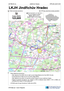
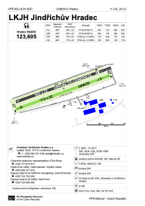


LKJH - Jindrichuv Hradec
Located in Jindrichuv Hradec, Czech Republic
ICAO - LKJH, IATA -
Data provided by AirmateGeneral information
Coordinates: N49°9'3" E14°58'18"
Elevation is 1683 feet MSL.
View others Airports in South Bohemian Region
Operational data
Special qualification required
Current time UTC:
Current local time:
Weather at : - ( 0 km )
METAR: TXKF 112055Z 22022KT 9999 VCSH BKN013 BKN026 BKN050 24/22 Q1006
Communications frequencies: [VIEW]
Runways:
| RWY identifier | QFU | Length (ft) | Width (ft) | Surface | LDA (ft) |
| 07R | 0° | 2526 | 72 | UNK | |
| 25L | 0° | 2526 | 72 | UNK | |
| 07L | 0° | 2274 | 72 | UNK | |
| 25R | 0° | 2274 | 72 | UNK |
Airport contact information
Address: Jindrichuv Hradec Czech Republic

