


LKCHVO - Chvojenec
Located in Holice, Czech Republic
ICAO - , IATA -
Data provided by AirmateGeneral information
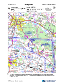
Coordinates: N50°6'31" E15°55'38"
Elevation is 793 feet MSL.
View others Airports in Pardubice Region
Operational data
Special qualification required
Current time UTC:
Current local time:
Weather at : LKPD - Pardubice ( 17 km )
METAR: LKPD 121300Z VRB03KT CAVOK 19/08 Q1020 NOSIG RMK BLU BLU
TAF: TAF LKPD 121100Z 1212/1312 11008KT CAVOK PROB30 TEMPO 1212/1216 7000 SHRA BKN035TCU
Communications frequencies: [VIEW]
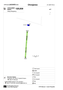
Runways:
| RWY identifier | QFU | Length (ft) | Width (ft) | Surface | LDA (ft) |
| 18 | 5° | 984 | 49 | GRASS | |
| 36 | 185° | 984 | 49 | GRASS | 984 |
Airport contact information
Address: Holice Czech Republic