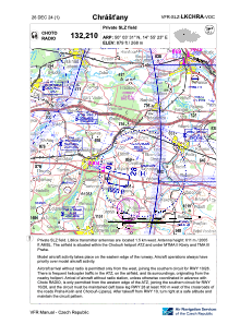
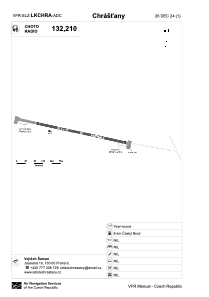


LKCHRA - Chrastany
Located in Český Brod, Czech Republic
ICAO - , IATA -
Data provided by AirmateGeneral information
Coordinates: N50°3'31" E14°55'23"
Elevation is 879 feet MSL.
View others Airports in Prague (capital city)
Operational data
Special qualification required
Current time UTC:
Current local time:
Weather at : LKKB - Kbely ( 28 km )
METAR: LKKB 131700Z 09009KT 9999 FEW047 21/07 Q1014 NOSIG
TAF: TAF LKKB 131100Z 1312/1412 08008KT CAVOK BECMG 1409/1411 14014KT
Communications frequencies: [VIEW]
Runways:
| RWY identifier | QFU | Length (ft) | Width (ft) | Surface | LDA (ft) |
| 10 | 103° | 1115 | 49 | ASPH | 1115 |
| 28 | 283° | 1115 | 49 | ASPH | 1115 |
Airport contact information
Address: Český Brod Czech Republic