


LKCHAR - Charvatce
Located in Louny, Czech Republic
ICAO - , IATA -
Data provided by AirmateGeneral information
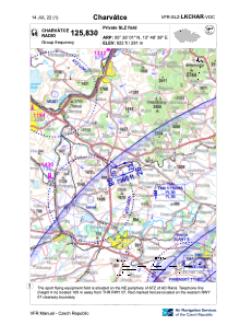
Coordinates: N50°26'1" E13°48'41"
Elevation is 922 feet MSL.
View others Airports in Ústí nad Labem Region
Operational data
Special qualification required
Current time UTC:
Current local time:
Weather at : LKVO - Praha/Vodochody ( 48 km )
METAR: LKVO 101200Z VRB04KT CAVOK 20/05 Q1023
Communications frequencies: [VIEW]
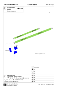
Runways:
| RWY identifier | QFU | Length (ft) | Width (ft) | Surface | LDA (ft) |
| 08 | 68° | 1312 | 66 | GRASS | 1312 |
| 26 | 248° | 1312 | 66 | GRASS | 1312 |
| 07 | 67° | 863 | 49 | GRASS | 863 |
| 25 | 247° | 863 | 49 | GRASS | 863 |
Airport contact information
Address: Louny Czech Republic