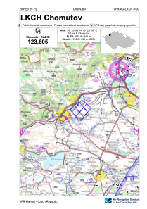
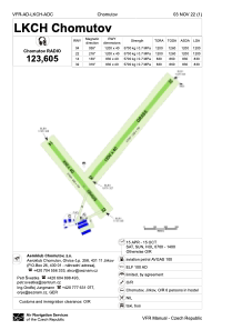


LKCH - Chomutov
Located in Chomutov, Czech Republic
ICAO - LKCH, IATA -
Data provided by AirmateGeneral information
Coordinates: N50°28'8" E13°28'5"
Elevation is 1132 feet MSL.
View others Airports in Ústí nad Labem Region
Operational data
Special qualification required
Current time UTC:
Current local time:
Weather at : LKKV - Karlovy Vary ( 49 km )
METAR: LKKV 100000Z 18001KT CAVOK 07/04 Q1024
TAF: TAF LKKV 092300Z 1000/1100 VRB02KT CAVOK TEMPO 1010/1018 05007KT 9999 SCT030
Communications frequencies: [VIEW]
Runways:
| RWY identifier | QFU | Length (ft) | Width (ft) | Surface | LDA (ft) |
| 14 | 0° | 2723 | 131 | UNK | |
| 32 | 0° | 2723 | 131 | UNK | |
| 04 | 0° | 3937 | 131 | UNK | |
| 22 | 0° | 3937 | 131 | UNK |
Airport contact information
Address: Chomutov Czech Republic

