


LKCEBI - Cebin
Located in Kurim, Czech Republic
ICAO - , IATA -
Data provided by AirmateGeneral information
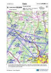
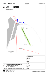
Coordinates: N49°19'8" E16°29'48"
Elevation is 1004 feet MSL.
View others Airports in South Moravian Region
Operational data
Special qualification required
Current time UTC:
Current local time:
Weather at : LKTB - Brno/Turany ( 23 km )
METAR: LKTB 120100Z 32002KT CAVOK 14/09 Q1020 NOSIG
TAF: TAF LKTB 112300Z 1200/1300 05008KT CAVOK
Communications frequencies: [VIEW]
Runways:
| RWY identifier | QFU | Length (ft) | Width (ft) | Surface | LDA (ft) |
| 15 | 155° | 1247 | 49 | GRASS | 1247 |
| 33 | 335° | 1247 | 49 | GRASS | 1247 |
Airport contact information
Address: Kurim Czech Republic