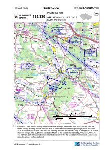
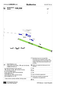


LKBUDK - Budkovice
Located in Ivan, Czech Republic
ICAO - , IATA -
Data provided by AirmateGeneral information
Coordinates: N49°4'43" E16°21'21"
Elevation is 870 feet MSL.
Magnetic variation is 4° East View others Airports in South Moravian Region
Operational data
Special qualification required
Current time UTC:
Current local time:
Weather at : LKNA - Namest ( 19 km )
METAR: LKNA 110630Z 31005KT CAVOK 12/06 Q1022 RMK BLACK
TAF: TAF LKNA 110500Z 1106/1206 33006KT CAVOK TEMPO 1109/1206 03005KT 9999 BKN045 PROB40 TEMPO 1110/1118 9999 SHRA BKN035TCU
Communications frequencies: [VIEW]
Runways:
| RWY identifier | QFU | Length (ft) | Width (ft) | Surface | LDA (ft) |
| 12 | 111° | 1640 | 49 | GRASS | 1640 |
| 30 | 291° | 1640 | 49 | GRASS | 1640 |
| 11 | 114° | 478 | 37 | DIRT | |
| 29 | 294° | 478 | 37 | DIRT |
Airport contact information
Address: Ivan Czech Republic