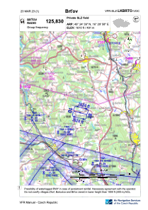


LKBRTO - Brtov
Located in Tišňov, Czech Republic
ICAO - , IATA -
Data provided by AirmateGeneral information
Coordinates: N49°24'39" E16°29'58"
Elevation is 1611 feet MSL.
View others Airports in South Moravian Region
Operational data
Special qualification required
Current time UTC:
Current local time:
Weather at : LKTB - Brno/Turany ( 32 km )
METAR: LKTB 130900Z 13009KT 110V170 CAVOK 17/02 Q1019 NOSIG
TAF: TAF LKTB 130500Z 1306/1406 08007KT CAVOK BECMG 1306/1308 15010KT BECMG 1320/1322 07005KT
Communications frequencies: [VIEW]
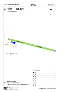
Runways:
| RWY identifier | QFU | Length (ft) | Width (ft) | Surface | LDA (ft) |
| 10 | 105° | 1312 | 49 | GRASS | 1312 |
| 28 | 285° | 1312 | 49 | GRASS | 1312 |
Airport contact information
Address: Tišňov Czech Republic