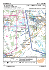
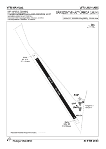


LHUH - Sarszentmihaly-Urhida
Located in Sarszentmihaly, Hungary
ICAO - , IATA -
Data provided by AirmateGeneral information
Coordinates: N47°7'35" E18°18'42"
Elevation is 653 feet MSL.
View others Airports in Fejér
Operational data
Special qualification required
Current time UTC:
Current local time:
Weather at : LHPA - Papa ( 67 km )
METAR: LHPA 171715Z 04009KT 360V070 9999 -SHRA FEW033CB SCT040TCU 15/13 Q1011 TEMPO 5000 -SHRA -TSRA RMK BLU
TAF: TAF LHPA 171715Z 1718/1818 34007KT 9999 FEW030TCU SCT040 TEMPO 1718/1721 VRB20G35KT 5000 SHRA TSRA SCT030CB BKN040TCU BECMG 1719/1721 VRB03KT BECMG 1721/1724 3000 BR NSC PROB40 TEMPO 1800/1806 0600 FG BKN005 BECMG 1806/1809 9999 NSW BKN020 BECMG 1810/1813 18006KT 9999 SCT040
Communications frequencies: [VIEW]
Runways:
| RWY identifier | QFU | Length (ft) | Width (ft) | Surface | LDA (ft) |
| 06 | 0° | 2133 | 98 | GRASS | |
| 24 | 0° | 2133 | 98 | GRASS |
Airport contact information
Address: Sarszentmihaly Hungary