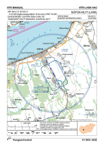


LHSK - Siofok-Kiliti
Located in Siofok, Hungary
ICAO - LHSK, IATA -
Data provided by AirmateGeneral information
Coordinates: N46°51'37" E18°5'37"
Elevation is 420 feet MSL.
View others Airports in Somogy
Operational data
Special qualification required
Current time UTC:
Current local time:
Weather at : LHPA - Papa ( 72 km )
METAR: LHPA 101615Z 36007KT CAVOK 21/05 Q1019 NOSIG RMK BLU
TAF: TAF LHPA 101115Z 1012/1112 36008KT CAVOK PROB30 TEMPO 1012/1018 9999 SCT060TCU BECMG 1019/1022 VRB03KT BECMG 1106/1108 01008KT PROB30 TEMPO 1108/1112 9999 SCT060TCU BKN200
Communications frequencies: [VIEW]
Runways:
| RWY identifier | QFU | Length (ft) | Width (ft) | Surface | LDA (ft) |
| 15L | 0° | 4101 | 164 | GRASS | |
| 33R | 0° | 4101 | 164 | GRASS | |
| 15R | 0° | 1969 | 59 | ASPH | |
| 33L | 0° | 1969 | 59 | ASPH |
Airport contact information
Address: Siofok Hungary