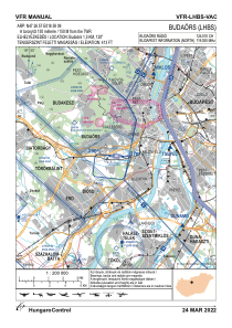
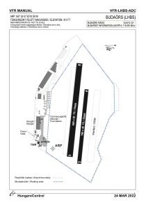


LHBS - Budaors
Located in Budaors, Hungary
ICAO - LHBS, IATA -
Data provided by AirmateGeneral information
Coordinates: N47°26'57" E18°59'9"
Elevation is 413 feet MSL.
Magnetic variation is 3.7° East View others Airports in Budapest
Operational data
Special qualification required
Current time UTC:
Current local time:
Weather at : LHBP - Budapest/Liszt Ferenc International Airport ( 21 km )
TAF: TAF LHBP 100515Z 1006/1106 VRB03KT CAVOK TEMPO 1006/1013 09008KT PROB30 TEMPO 1012/1018 -SHRA SCT055TCU BKN070 TEMPO 1013/1017 36008KT BECMG 1023/1102 07008KT
Communications frequencies: [VIEW]
Runways:
| RWY identifier | QFU | Length (ft) | Width (ft) | Surface | LDA (ft) |
| 09R | 0° | 3215 | 197 | GRASS | |
| 27L | 0° | 3215 | 197 | GRASS | |
| 09L | 0° | 2559 | 131 | GRASS | |
| 27R | 0° | 2559 | 131 | GRASS |
Airport contact information
Address: Budaors Hungary