


LHAK - Atkar-Gyongyoshalasz
Located in Atkar, Gyongyoshalasz, Hungary
ICAO - , IATA -
Data provided by AirmateGeneral information
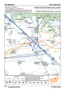
Coordinates: N47°43'17" E19°54'13"
Elevation is 364 feet MSL.
View others Airports in Heves
Operational data
Special qualification required
Current time UTC:
Current local time:
Weather at : LHBP - Budapest/Liszt Ferenc International Airport ( 57 km )
METAR: LHBP 210530Z 09009KT 060V120 9999 FEW010 SCT140 18/15 Q1012 NOSIG
TAF: TAF LHBP 210515Z 2106/2206 08008KT CAVOK BECMG 2106/2109 11012G22KT TEMPO 2106/2110 SCT035 BKN150 TEMPO 2117/2120 22022G35KT 4000 TSRAGR SHRA SQ SCT040CB BKN060 TEMPO 2120/2124 VRB10KT 2000 +SHRA TSRA BKN014 SCT020CB BKN040 BECMG 2122/2124 06006KT SCT012 BKN020 TEMPO 2200/2206 VRB02KT 2000 -RA DZ BR BKN004 OVC014
Communications frequencies: [VIEW]
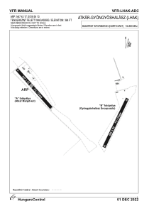
Runways:
| RWY identifier | QFU | Length (ft) | Width (ft) | Surface | LDA (ft) |
| 02 | 0° | 2290 | 131 | GRASS | |
| 20 | 0° | 2290 | 131 | GRASS | |
| 13 | 0° | 2188 | 131 | GRASS | |
| 31 | 0° | 2188 | 131 | GRASS |
Airport contact information
Address: Atkar, Gyongyoshalasz Hungary