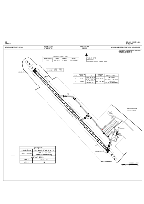


LGKM - Kavala / Amigdaleon Lydia
Located in Kavala, Greece
ICAO - LGKM, IATA -
Data provided by AirmateGeneral information
Coordinates: N40°58'23" E24°20'29"
Elevation is 199 feet MSL.
Magnetic variation is 5° East View others Airports in Kavala
Operational data
Special qualification required
Current time UTC:
Current local time:
Weather at : LGKV - Kavala / Megas Alexandros ( 24 km )
METAR: LGKV 151820Z 02004KT 9999 FEW030 BKN070 16/08 Q1018
TAF: TAF LGKV 151700Z 1518/1618 07008KT 9999 SCT025 BKN080 PROB40 1610/1618 5000 RA BKN025 OVC080
Communications frequencies: [VIEW]
Runways:
| RWY identifier | QFU | Length (ft) | Width (ft) | Surface | LDA (ft) |
| 13 | 137° | 4364 | 92 | UNK | |
| 31 | 317° | 4364 | 92 | UNK | |
| 32 | 0° | 0 | 0 | ASPH | |
| 14 | 0° | 0 | 0 | ASPH |
Airport contact information
Address: Kavala Greece