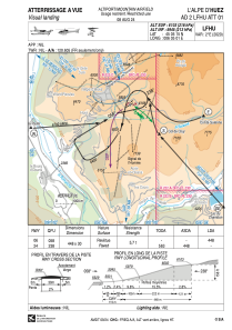


LFHU - L'alpe D'huez
Located in , France
ICAO - LFHU, IATA - AHZ
Data provided by AirmateGeneral information
Coordinates: N45°5'15" E6°5'1"
Elevation is 6103 feet MSL.
Magnetic variation is 2.14° East View others Airports in Rhône Alpes
Operational data
Special qualification required
Current time UTC:
Current local time:
Weather at : LFLB - Chambery Aix Les Bains ( 63 km )
METAR: LFLB 151800Z AUTO 21002KT 9999 BKN074/// BKN094/// OVC110/// //////TCU 15/13 Q1007 TEMPO VRB15G25KT 4000 SHRA BKN012 BKN030CB
TAF: TAF LFLB 151400Z 1515/1615 VRB05KT 9999 BKN050 TEMPO 1515/1524 4000 SHRA BKN014 BKN035TCU PROB40 TEMPO 1515/1519 VRB15G25KT 2000 TSRA BKN012 BKN030CB PROB30 TEMPO 1600/1606 2000 BR BKN004 TEMPO 1610/1615 SHRA SCT030TCU BKN050 PROB30 TEMPO 1612/1615 VRB15KT 2500 TSRA BKN025CB
Communications frequencies: [VIEW]
Runways:
| RWY identifier | QFU | Length (ft) | Width (ft) | Surface | LDA (ft) |
| 06 | 60° | 1470 | 98 | ASPH | 1470 |
| 24 | 240° | 1470 | 98 | ASPH |
Airport contact information
Address: France