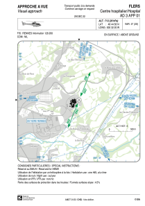


LFH481 - Flers Centre Hospitalier
Located in , France
ICAO - , IATA -
Data provided by AirmateGeneral information
Coordinates: N48°44'58" W0°32'20"
Elevation is 712 feet MSL.
View others Airports in Lower Normandy
Operational data
Special qualification required
Current time UTC:
Current local time:
Weather at : LFRK - Caen Carpiquet ( 48 km )
METAR: LFRK 221100Z AUTO 25016KT 9999 FEW009 SCT027 BKN033 18/12 Q1012 TEMPO 26015G25KT 2000 TSRAGS BKN020CB
TAF: TAF LFRK 220800Z 2209/2218 25013KT 9999 SCT015 BKN025 PROB40 TEMPO 2209/2213 26015G25KT 4000 SHRA BKN020CB PROB30 TEMPO 2211/2213 2000 TSRAGS
Communications frequencies: [VIEW]
Runways:
Airport contact information
Address: France