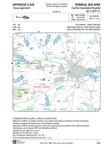


LFH388 - Verneuil Sur Avre Centre Hospitalier
Located in , France
ICAO - , IATA -
Data provided by AirmateGeneral information
Coordinates: N48°44'40" E0°53'30"
Elevation is 597 feet MSL.
Magnetic variation is 0.58° East View others Airports in Upper Normandy
Operational data
Special qualification required
Current time UTC:
Current local time:
Weather at : LFOE - Evreux Fauville ( 40 km )
METAR: LFOE 220500Z AUTO 22007KT 210V280 7000 FEW013 BKN021 12/11 Q1010 TEMPO 4000 BR BKN009
TAF: TAF AMD LFOE 220420Z 2204/2303 25005KT 7000 BKN015 TEMPO 2204/2207 4000 BR BKN009 TEMPO 2209/2220 VRB15G25KT 4000 SHRA BKN020CB PROB40 TEMPO 2214/2218 VRB15G30KT 2000 TSRAGS
Communications frequencies: [VIEW]
Runways:
Airport contact information
Address: France