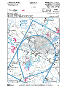


LFH334 - Nantes Atlantique
Located in , France
ICAO - , IATA -
Data provided by AirmateGeneral information
Coordinates: N47°9'25" W1°36'28"
Elevation is 90 feet MSL.
Magnetic variation is -0.08° East View others Airports in Pays-de-la-Loire
Operational data
Special qualification required
Current time UTC:
Current local time:
Weather at : LFRS - Nantes Atlantique ( 0 km )
TAF: TAF LFRS 171700Z 1718/1824 18008KT 9999 BKN025 PROB40 TEMPO 1719/1724 4000 SHRA BKN025CB PROB40 TEMPO 1718/1719 2000 TSRA BKN012 BKN020CB TEMPO 1803/1807 4000 BR PROB30 TEMPO 1804/1807 0500 FG VV/// TEMPO 1807/1812 SCT030TCU TEMPO 1812/1818 3000 SHRA SCT030CB PROB30 1812/1818 TSRA
Communications frequencies: [VIEW]
Runways:
Airport contact information
Address: France