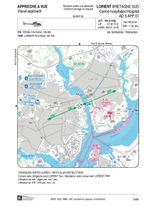


LFH328 - Lorient Bretagne Sud Centre Hospitalier
Located in , France
ICAO - , IATA -
Data provided by AirmateGeneral information
Coordinates: N47°45'13" W3°21'22"
Elevation is 100 feet MSL.
Magnetic variation is -0.70° East View others Airports in Brittany
Operational data
Special qualification required
Current time UTC:
Current local time:
Weather at : LFRH - Lorient Lann Bihoue ( 6 km )
TAF: TAF AMD LFRH 220540Z 2206/2306 28010KT 9999 SCT017 TEMPO 2206/2214 -SHRA SCT020CB TEMPO 2214/2220 28010G25KT 4000 SHRA SCT020CB BECMG 2220/2222 SCT040 PROB40 TEMPO 2301/2306 2000 BR PROB30 TEMPO 2304/2306 3000 SHRA BKN008 BKN012CB
Communications frequencies: [VIEW]
Runways:
Airport contact information
Address: France